Epic flooding leads to water rescues and highway closures in California as the storm system threatens more states
By Nouran Salahieh, Holly Yan and Haley Brink, CNN
More than 15 million people from the West Coast to Wisconsin are under winter weather alerts Sunday as a storm system causing life-threatening flooding in California pushes east.
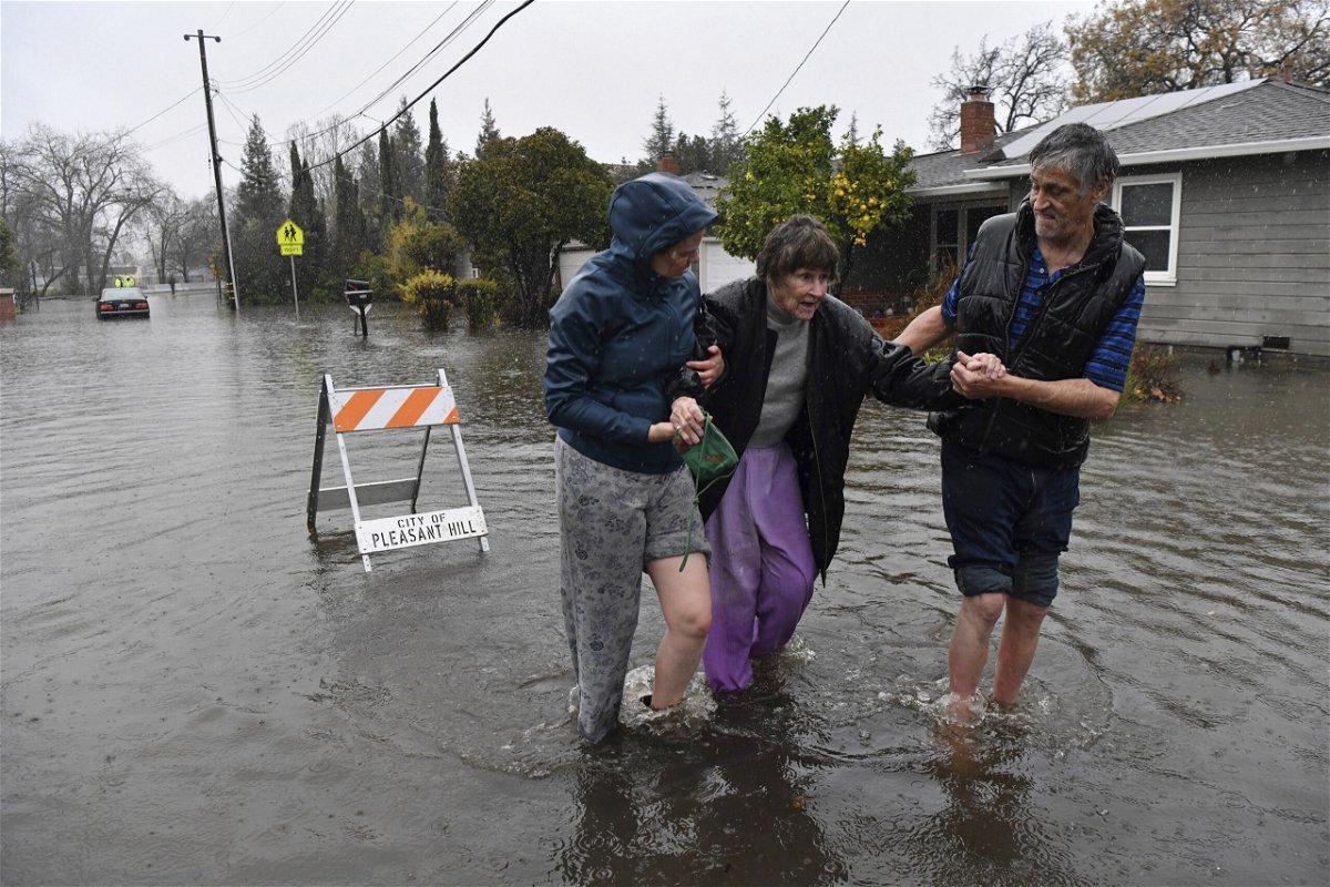
At least two people have been killed and scores of others rescued from the flooding in portions of northern California over the weekend.
Thousands of Californians are still grappling with power outages or impassable roads Sunday after high winds and record-setting rainfall battered the state.
One person in southern Sacramento County was found dead Saturday inside a completely submerged vehicle on a roadway, while a 72-year-old man was killed after being struck by a fallen tree at a state park in Santa Cruz, according to officials.
Emergency crews in Sacramento have also rescued multiple flood victims by helicopter since the city started getting deluged Saturday. At least one was “in critical condition after exiting a vehicle and being washed off the roadway and trapped in the cold water,” the Sacramento Metropolitan Fire District said Sunday.
Crews have also “responded to fallen trees on homes and vehicles, disabled vehicles due to drivers pushing through standing water, floodings, water rescues, and more,” the fire agency said.
The Sacramento County Office of Emergency Services issued an evacuation warning Sunday to residents living in the areas of Point Pleasant, Glanville Tract, and Franklin Pond. The agency said residents of those areas should prepare to leave before roadways are cut off.
“It is expected that the flooding from the Cosumnes River and the Mokelumne River is moving southwest toward I-5 and could reach these areas in the middle of the night,” the agency tweeted. “Livestock in the affected areas should be moved to higher ground.”
In nearby San Joaquin County, floodwaters Sunday forced the shutdown of all northbound lanes of a stretch of State Route 99, the California Department of Transportation’s District 10 tweeted. “SR 99 is one of the state’s heavily traveled, and commercially important, corridors,” its website adds.
The city of Oakland had its wettest day on record Saturday, with 4.75 inches of rain in a 24-hour period — beating the previous record set on January 4, 1982, the National Weather Service office in San Francisco said.
The severe weather was caused by a powerful atmospheric river, a long, narrow region in the atmosphere which can carry moisture thousands of miles, like a fire hose in the sky.
Now, as the same storm system heads east, it could dump a foot of snow across the Sierras and up to 2 feet of snow in parts of the Rockies by late Monday. Local forecasters warn travel could be difficult.
More than 200,000 left in the dark
The severe weather, which included high winds, left about 235,000 homes, businesses and other power customers without electricity in California and Nevada on Sunday, according to Poweroutage.US.
The storm also forced some Northern California residents out of their homes on New Year’s Eve as streets started to flood and evacuation orders and warnings were issued.
In addition to urban flooding, several rivers started overflowing, including the Cosumnes and Mokelumne rivers and the Mormon Slough, according to the weather service in Sacramento.
Despite the flooding headaches, the moisture is actually a relief for drought-stricken California, which started 2022 with the driest beginning of the year on record and ended the year with drenched roadways and thick mountain snow.
It’s not clear how much the storm will make a dent in California’s drought conditions.
‘Too many road closures to count’
Officials ordered residents in Wilton, California, to leave the area immediately at one point Saturday — warning rising water could spill onto roadways and cut off access to the area. But two hours later, Wilton residents were told to shelter in place after water made roads “impassable.”
Three communities near the city of Watsonville were also told to evacuate by the Santa Cruz County Sheriff’s Office due to creek flooding, while rising San Lorenzo River waters prompted evacuations in the communities of Paradise Park and Felton.
In San Ramon, police used an armored rescue vehicle to evacuate residents from floodwaters.
“Flooding impacts continue to escalate as this rain continues with too many road closures to count at this point,” the National Weather Service said Saturday. The weather service told residents to stay put amid reports of rock and mudslides across the foothills and road closures across the Sierra passes.
Sacramento Metropolitan Fire District crews performed water rescues and responded to drivers whose vehicles became disabled after they drove through standing water Saturday, officials said.
Calling it “Stormageddon,” the Amador County Sheriff’s Office shared an image of cars up to their door handles in floodwaters.
Highway 50 reopened just after midnight, hours after a section between Pollock Pines and Meyers was closed due to flooding from the American River. Another section was closed over Echo Summit for avalanche control work.
Interstate 80 was also partially closed near the Nevada line Saturday “due to multiple spinouts over Donner Summit,” the California Department of Transportation said.
By late Sunday morning, I-80 in the Sierra-Nevada Mountains had reopened to passenger vehicles only, “with R2 chain restrictions,” California Highway Patrol in Truckee tweeted. The restriction means chains or traction devices are required on all except four-wheel-drive vehicles with snow tires on all four wheels.
“The roads are extremely slick so let’s all work together and SLOW DOWN so we can keep I-80 open,” the agency said.
US Highway 101 — one of California’s most famous routes — was also temporarily closed in both directions in South San Francisco with the California Highway Patrol reporting “water is not receding due to non-stop rainfall & high tides preventing the water to displace.”
In the Sacramento County area, residents were advised to avoid travel as wind gusts of up to 55 mph toppled trees and covered roads with debris, according to a tweet from the weather service in Sacramento.
The county proclaimed a state of emergency, saying the atmospheric river has caused “significant transportation impacts, rising creek and river levels and flooding” in the Wilton area.
Downtown San Francisco got 5.46 inches Saturday, making it the second-wettest day on record for the area, according to the weather service in the Bay Area.
This heavy rainfall is expected to slide southward to Southern California on Sunday, accompanied by gusty winds of 30 to 50 mph.
Sierra Nevada range get walloped with snow
While parts of Northern California grapple with heavy rainfall, mountainous areas are getting covered with snow.
The UC Berkeley Central Sierra Snow Lab reported 7.5 inches of snowfall per hour between 4 and 5 p.m. Saturday in Soda Springs, about 30 miles from Lake Tahoe, and shared video of thick snow blanketing the area.
The lab said it had unofficial measurements of more than 30 inches of snow on Saturday.
Over a foot of new snow fell at Mammoth Mountain’s Main Lodge on Saturday, the ski resort said on Facebook, adding work will take place across the mountain since all lifts were coated in ice and “avalanche danger is extremely high.”
The-CNN-Wire
™ & © 2023 Cable News Network, Inc., a Warner Bros. Discovery Company. All rights reserved.
CNN’s Michelle Watson and Tina Burnside contributed to this report.